Day 1
Left home early in the morning, around 4 am! It was an over 12 hour trip from home to Santa Rosa, NM, our first stop. Ate breakfast in Waco after stopping at H-E-B for gas (and because we were a little lost). I drove up to this point – from here on out my mom drove. Kept driving. Ate lunch in the car after filling up for gas at a small town outside Lubbock called Shallowater. Kept driving. Arrived in Santa Rosa around 4:30 pm (Mountain Time, not Central Time anymore otherwise it was 5:30). I took a short nap (switching from night to day schedule while spending all day in a vehicle isn’t easy) while my parents took a short walk around town. Ate dinner at a Mexican place.
Distance walked: 4.57 miles
Day 2
Got up early, but not as early as yesterday. Most days from here on out we are up before or by 7 am. Drove to Albuquerque, NM. Stopped for breakfast at Weck’s and had some delicious oatmeal. It ended up being the perfect place because the low tire pressure light had come on in the car as we were leaving Santa Rosa and neither of the gas stations there had an air pump. It just so happened that right next to Weck’s was a Discount Tire and they were offering free tire pressure checks. So we drove up and they fixed the problem in no time. Then it was off to Petroglyph National Monument which wasn’t too far away. Spent a good chunk of the day there and walked along the three main trails, eating lunch after finishing the second one. After finishing the third trail, we drove to Holbrook, AZ. Luckily we weren’t heading the other way on I-40 into Albuquerque as an accident had caused the closure of the interstate and the backup was miles long.
Distance walked: 7.87 miles
Day 3
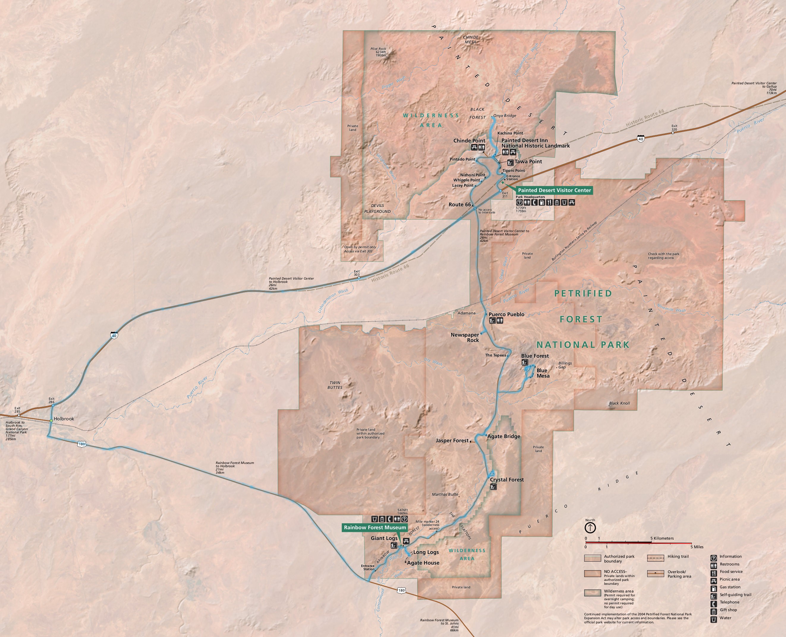
We spent the whole day in Petrified Forest National Park. We visited the northern part of the park first (map), stopping at Tawa Point and the Painted Desert Inn, which was unfortunately closed to due Covid-19. At the Inn, we left the beaten path and hiked to Onyx Bridge. There is a well marked path for the first part of the trail, but you soon leave that behind and are just walking across the desert, past an old bridge, across a wash, towards the hills, and up a canyon to get to the Onyx Bridge. The “bridge” is a confer tree from the Triassic period and is around 210 million years old. After hiking back to the Inn, we drove to the Puerco Pueblo to have lunch and walk around the pueblo site. Then we visited newspaper Rock (a rock with a bunch of petroglyphs), Blue Mesa (where we hiked a short but steep trail), Agate Bridge, Crystal Forest (where there are some really long trees), and finally Giant Logs (which is a short hike where you can see the biggest tree in the park). We had roughly 45 minutes till the park closed and I really wanted to see the Long Logs and the Agate House, but there wasn’t enough time so I jogged part of the way down that trail to see the ancient log jam area that is Long Logs and also got a distant view of the Agate House before turning back. My dad even walked most of the trail I took even though he had been complaining about blisters. On our way back to Holbrook, we stopped at a rock store where we bought some Arizona petrified wood.
Distance walked: 12.28 miles
Day 4
Most of today was spent driving to the southern rim of the Grand Canyon. Just before we got to Flagstaff, we stopped at Walnut Canyon National Monument. In fact, we arrived there just after they opened at 9am. We hiked along the two short trails that describe the history of the Native Americans that lived there several hundred years ago in houses built under overhangs in the canyon walls. Once we got to the Grand Canyon, because we were still too early to check in at Maswik Lodge, we walked along the Trail of Time (Rim Trail) from Verkamp’s Visitor Center to the Geology Museum and back. After dinner, we drove back to the Geology Museum so I could try to get some pictures of the stars and Milky Way. I really didn’t know what I was doing at first, but I learned a lot and even got some decent pictures.
Distance walked: 9.54 miles
Day 5
The hike from the first to last bus stop along Hermit Road is around 8 miles. We weren’t really sure if we wanted to hike the whole trail, if we had enough water, or which direction we wanted to hike (out to Hermit’s Rest or back to the Village). I decided we would ride the bus all the way out and then walk back and if we got too tired or ran out of water, we could stop at one of the bus stops and just catch the bus. We ended up walking all the way back. The views along the trail were absolutely amazing and at one point you could even hear the Colorado River in the distance. After eating some lunch back in the room, we decided we hadn’t quite hiked enough yet and headed to the Bright Angel Trail and hiked down it a short distance (to the big switchback past the first arch). Then it was back to the room to rest as we were all tired after a long day outside. I had planned to go take more pictures of the stars, but was just too tired.
Distance walked: 12.5 miles
Day 6
Today we left the Grand Canyon and headed to Page, but not without a few stops along the way. I got up early, just before sunrise, and took the bus to Powell Point to get some pictures of the sunrise. On my way back to the room, I saw several mule deer, two of which were walking around the lodge parking lot. We left early so we could have as much time as possible at our two stops of the day: Sunset Crater Volcano National Monument and Wupatki National Monument. Sunset Crater, our first stop, has some beautiful trails that lead you onto lava flows and an old cinder cone (Lenox crater). Our second stop, Wupatki, is where we ended up spending most of our day. There were so many old ruins to see, every outcropping seemed to harbor traces of old buildings. It is amazing to think that the land here, that is now fairly empty of people, was once home to so many. We didn’t get to Page until early evening.
Distance walked: 7.98 Miles
Day 7
Day 8
Day 9
Day 10
Day 11
Day 12
Day 13
Today we hiked the Fairyland Loop Trail from Sunrise Point, including the short side trip to Tower Bridge (map, blue highlighted trails). It was a breathtaking hike, due to both the amazing scenery and the up-and-down nature of the trail. I would say this hike was my favorite one in Bryce out of the ones we did. After getting back to the car, we ate lunch by the general store. Then we drove the rest of the way down the park road to Rainbow Point where we did another hike, this time the Bristlecone Trail which was thankfully short as I was worn out. On our way back out of the park, we stopped at the Natural Bridge overlook as well as the visitor center to inquire about stargazing. Turns out they leave a gate open all night and you can just drive in. We ate dinner at Ruby’s Inn, where I had two appetizers instead of an entrée, which was a bit too much food, and afterwards my dad ended up buying a piece of pottery in the gift store. Later after the sun had set, we headed back in to the park so I could take pictures. Unfortunately, the moon was getting pretty full by now and wasn’t setting until after midnight, which made it nearly impossible to make out the Milky Way. It was also pretty cloudy. I did however, manage to get some really good pictures, perhaps the best ones of the trip. At the insistence of my parents, we finally drove back to the hotel after roughly an hour.
Distance walked: 15.15 miles
Day 14
Since we were a little exhausted from yesterday, we decided to do a shorter hike today with less elevation change. Okay, that’s a lie because we planned this out already and this hike wasn’t much shorter or less strenuous. Today we started with the Figure-8 Combination (map, orange highlighted trails), which is a combination of the Navajo Loop, Queen’s Garden, and Peekaboo Loop Trails. While I preferred the Fairyland Loop Trail, in part because there were less people, this combined trail was also beautiful. Just watch out for the horse poop! Afterwards we went back to the hotel for lunch (leftover dinner from the previous night for me). Then after a little rest, which mostly consisted of listening to my dad snore, we drove around to the Mossy Cave Trail. It was a nice little trail that led to a small waterfall and cave (I’d call it more of an overhang). My biggest gripe was all the people who completely ignored the “do not walk here” signs and roped off areas. For dinner we ate at Ruby’s Inn again. Afterwards we drove across the street and walked to the rock shop, where I ended up buying a couple small pieces. Later that night, some time after 2am, I drove back into the park to get some pictures after the moon had set and spent around an hour outside.
Distance walked: 12.67 miles